
MAPS VIDEO LINK
NOTES
• A map is a representation or a drawing of earth’s surface or part of it, drawn on a flat surface according to a scale.
• Type:
(i) Maps are of several types.
(ii) Maps showing natural features of the earth such as mountains ,plateaus,plains,rivers oceans etc are called physical or relief maps.
(iii) Maps showing cities, town and villages, countries and states of the world with their boundaries are called political maps.
(iv) Some maps focus on specific information like rainfall map, road maps, maps of tourist places are called thematic maps.
• Components of Maps:
(i) There are three components of maps-distance, direction and symbol.
(ii) Distance is measured in terms of scale. Scale is the ration between the actual distance on the ground and the distance shown on the map.
(iii) When large areas like contintents or countries are to be shown on a paper, then we use a small scale.For example,2cm on the map shows 200km of the ground.
(iv) When a small area like your village to town in to be shown on paper, then we use a large scale map.For example,2cm on the map shows 200metre on the ground.
(v) Directions are cardinal points like North, South, East and West.North-East,South-East, South-West,North-West are other four directions which are called intermediate directions.
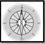
(vi) Direction of a place can be found out with the help of an instruement called Compass.Its magnetic needle always points towards the North-South direction.
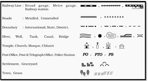
(vii) Symbols are certain letters, shades, colours, pictures and lines, which give us information in a limited space.The maps have a universal language so that it can be understood by the people speaking any language.
(viii) There is an international agreement regarding the use of these symbols and these are called conventional symbols.
Various other things like sketches and plan are used to draw an area of a large scale.
Sketch: A sketch is a drawing mainly based on memory and spot observation and not to scale.Sometimes a rough sketch is required of an area to tell,where a particular area is located with respect to other places.Such a rough drawing is called a sketch map.
Plan: A plan is a drawing of a small area on a large scale or in other words,adrawing drawn to scale is called a plan.
Exercise
Question 1: Answer the following questions briefly.
- What are the three components of a map?
- What are the four cardinal directions?
- What do you mean by the term ‘the scale of the map’?
- How are maps more helpful than a globe?
- Distinguish between a map and a plan.
- Which map provides detailed information?
- How do symbols help in reading maps?
Answer:
- Distance, direction, and symbols are the three components of a map.
- North, South, East, and West are the four cardinal directions.
- The ratio between the actual distance on the ground and the distance shown on the map is 'the scale of the map'.
- Maps provide us with more information than a globe. When we want to study the Earth as a whole, a globe is useful. But, when we want to study only a part of the Earth, it is of little help. We use maps for this purpose. The entire Earth’s surface or a part of it can be represented by a map.Maps can be used to show the physical features of the Earth such as mountains, plains, oceans, rivers, etc.; the political divisions of the Earth like countries, states, cities, villages, etc.; and certain specific information about roads, rainfall, forests, industries, etc.
Map Plan A map is a representation or a drawing of the Earth’s surface or a part of it drawn on a flat surface according to a scale. A plan is a drawing of a small area on a large scale. It can be used for representing large areas like continents or countries (small scale maps), and also for representing a small area like a village or a town (large scale maps). It is used for representing those things that cannot be represented in a map. For example, the length and the breadth of a room cannot be shown in a map. A plan is used for this purpose. - A large scale map provides detailed information than small scale maps. A large scale map only shows a small area like our village or town, but it shows it in great detail.
- It is not possible to draw on a map the actual shape and size of different features such as buildings, roads, bridges, trees, railway lines or a well. So, they are shown by using certain standard letters, shades, colours, pictures, and lines. These symbols give a lot of information in a limited space. Maps can be drawn easily using these symbols. The use of symbols makes maps simple to read. Even if one doesn't know the language of an area and therefore cannot ask someone for directions, one can collect information from maps with the help of these symbols.
Question 2: Tick the correct answers.
- Maps showing distribution of forests are
- Physical maps
- Thematic maps
- Political maps
- The blue colour is used for showing
- Water bodies
- Mountains
- Plains
- A compass is used
- To show symbols
- To find the main directions
- To measure distance
- A scale is necessary
- For a map
- For a sketch
- For symbols
Answer
- (ii) Thematic maps
- (i) Water bodies
- (ii) To find the main directions
- (i) For a map